| Fort Crawford The historic fort stood on a high bluff overlooking Murder Creek in what is now East Brewton, Alabama. It dates from the First Seminole War. |
Fort Crawford, Alabama
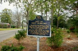
A marker that notes the site of Fort
Crawford stands in a residential area of
East Brewton, Alabama.
A marker that notes the site of Fort
Crawford stands in a residential area of
East Brewton, Alabama.
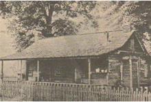
House from Fort Crawford
This structure was moved a short
distance from the original fort and
survived into the 20th century.
This structure was moved a short
distance from the original fort and
survived into the 20th century.
FORT CRAWFORD
Escambia County, Alabama
Escambia County, Alabama
Seminole War in Alabama
| Copyright 2017 by Dale Cox All rights reserved. Last Updated: August 15, 2017 (Some contents Copyright 2014) |

Custom Search
Forts & Battlefields of Alabama
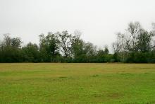
Site of Fort Crawford?
The only traces of the fort found by
archaeologists were in this open field
now owned by the city of East Brewton.
The only traces of the fort found by
archaeologists were in this open field
now owned by the city of East Brewton.
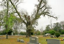
Ancient Oak Tree
This historic old oak at Fort Crawford
Cemetery may have been growing
when soldiers still manned the fort.
This historic old oak at Fort Crawford
Cemetery may have been growing
when soldiers still manned the fort.
Fort Crawford was built in 1816 atop a high
bluff in what is now East Brewton, Alabama.
The site of the fort is not developed, but a
historical marker at the intersection of
Shofner and Weaver Streets interprets its
history. No visible trace of Fort Crawford
remains.
In the months after the Battle of Horseshoe
Bend (March 27, 1814), refugee parties of
Red Stick Creeks made their way south into
the valleys of the Conecuh, Escambia and
Choctawhatchee Rivers. They were pursed
by U.S. troops, Choctaw warriors and even
some of their former allies led by William
Weatherford.
Multiple raids were launched against these
groups and Major General Andrew Jackson
attacked the Spanish city of Pensacola in
December of 1814. He drove out not only a
force of Red Stick Creek warriors, but also a
battalion of British Royal Marines who were
training, suppling and arming them.
Despite the success of such raids, the Red
Sticks survived as a potent fighting force.
They formed an alliance with the Seminole
Indians who then lived primarily from the
Apalachicola to the Suwannee River in
Florida. Attacks on settlers continued and
even though the Creek War of 1813-1814
was over, minor fighting went on into 1816.
Concerns that war parties would disrupt the
effort to survey land surrendered by the
Creeks to the United States under the Treaty
of Fort Jackson led to a decision to establish
a permanent fort somewhere near the mouth
of the Conecuh River.
To build this post, a detachment of soldiers
from the 7th U.S. Infantry was ordered to the
lower Conecuh in the late spring of 1816.
After exploring the area, they settled on a high
bluff on the east side of Murder Creek as the
best location for a new post. The creek is a
major tributary of the Conecuh River, which
flows about 2 miles south of the bluff.
The encampment was first called the "Camp
near Conaka" and the soldiers built a powder
magazine and temporary quarters until they
began work on the permanent fort. That
project began in August 1816 when Brevet
Major Richard Whartenby of the 7th Infantry
issued orders for the building of the fort:
An Officer, Sergeant, Corporal and thirty
privates will be detailed and reported on
Extra Duty, to prepare materials for erecting a
permanent work. - Bvt. Maj. R. Whartenby, August 5, 1816.
Whartenby ordered that all privates and
non-commissioned officers involved in the
work receive "an extra gill of whiskey each, for
each day employed on such duty."
In his orders, which were dated August 5,
1816, Whartenby first used the name Fort
Crawford for the new post.
The construction project was a major ordeal
for the men of the 7th U.S. Infantry. Heavy
logs were cut from the virgin forests and
dragged to the site for the fort, where they
were squared using hand tools.
Because the army did not need to build the
fort as a hasty defense, the soldiers were
tasked with building a much more elaborate
post.
Major John M. Davis visited Fort Crawford on
an inspection tour during the fall of 1816 and
filed his report the following year:
Battle of Ebenezer Church
Battle of Fort Blakeley
Battle of Holy Ground
Battle of Horseshoe Bend
Battle of Mobile Bay
Fort Conde Visitor Center
Fort Gaines Historic Site
Fort Mims State Historic Site
Fort Morgan State Historic Site
Fort Toulouse & Fort Jackson
Battle of Fort Blakeley
Battle of Holy Ground
Battle of Horseshoe Bend
Battle of Mobile Bay
Fort Conde Visitor Center
Fort Gaines Historic Site
Fort Mims State Historic Site
Fort Morgan State Historic Site
Fort Toulouse & Fort Jackson
The Fort…is a square log work with two Block
houses at diagonal angles. The buildings are
erected with square logs of about eight or ten
inches square. The barracks for the officers
and men form three squares of the Fort, the
Doctor’s shop, Guard House, and Artificers’
Shops form the fourth. The logs are laid so
close as to touch with port holes cut in them,
which makes the Fort a complete defence
against small arms. - Maj. J.M. Davis, April 1817.
Based on Major Davis' description, Fort
Crawford was not a normal stockade of
upright logs. Instead the four sides were
formed of log buildings. The outside walls of
the structures formed the walls of the fort.
Fort Crawford stood as an important defense
of the U.S. frontier for the next few years. In
the summer and fall of 1818, it served as a
base of operations for raids against Red
Stick Creeks in the Florida Panhandle by U.S.
and volunteer troops. Warriors taken prisoner
during these raids were temporarily housed
at the fort, along with their families.
These raids were part of a conflict known
today as the First Seminole War. It ranged
across South Alabama, South Georgia and
North Florida. The raids based from Fort
Crawford were among its westernmost
actions.
Although the First Seminole War ended in
1818, Fort Crawford remained an important
post on the southern frontier of the United
States for several more years. What is now
the Alabama-Florida state line was then the
boundary between the United States and
Spanish Florida.
The cession of Florida to the United States by
Spain in 1821, however, ended the need for
the fort and it was evacuated. The soldiers of
the 4th and 7th Infantry were withdrawn from
the region in September 1821.
A historical marker for Fort Crawford can be
seen at the intersection of Shofner and
Weaver Streets in East Brewton, Alabama.
Exhibits on the history the fort can be seen
nearby at the Thomas E. McMillan Museum
on the Jefferson Davis Community College
campus. The museum address is 220 Alco
Drive, Brewton, Alabama. It is open on
Tuesdays, Wednesdays and Thursdays from
9 am to 3 pm and is free to visit.

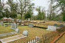
Fort Crawford Cemetery
Local tradition holds that this burial
ground adjacent to the fort site was first
used as the post cemetery.
Local tradition holds that this burial
ground adjacent to the fort site was first
used as the post cemetery.
Creek War of 1813-1814
Fort Mims State Historic Site
Home of William Barret Travis
Horseshoe Bend National Military Park
Historic Sites in Alabama
Forts & Battlefields of the South
Explore other Southern Historic Sites
Fort Mims State Historic Site
Home of William Barret Travis
Horseshoe Bend National Military Park
Historic Sites in Alabama
Forts & Battlefields of the South
Explore other Southern Historic Sites
